Geo Location
Default UI Menu: Options/Drawing Setup/Geo-Location
Ribbon UI Menu:
Geo-Location contains three primary functions: Location, Orientation, and Display.
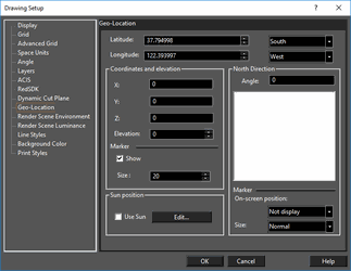 Location
- Latitude
– set the latitude of the drawing in degrees, to six decimal places.
-
South/North – specify whether the latitude angle is South or North
-
Longitude
– set the longitude the drawing in degrees, to six decimal places.
- East/West – specify whether the longitude angle is East or West
Coordinates and Elevation
-
X, Y, Z – specify the location in the drawing which corresponds to the geo-location. Units are in the model space defined Space units.
-
Elevation – specify the elevation of the drawing at that geo-location.
-
Marker
-
Show – When on this shows a crosshair marker within the drawing, located at as specified by the X, Y, Z values. This maker can be snapped to as a drawing reference.
- Size – Sets the relative size of the to the crosshair marker.
North Direction
-
Angle – Specify the Angle of orientation for North relative to the drawing.
-
Marker
– Displays a compass rose for drawing orientation
- On Screen Position – Specify the location of the compass rose: Not Display, Top Left, Bottom Right, Top Left, and Bottom Left.
- Size-- Sets the relative size of the compass rose: Tiny, Small, Normal, and Large.
Geo-Location Crosshairs and Compass Rose